NEW: All of Southeast Louisiana is under a FLOOD WATCH starting Wednesday afternoon to early Saturday morning. 3-6 inches of rainfall is possible, with areas along the coast seeing higher amounts.
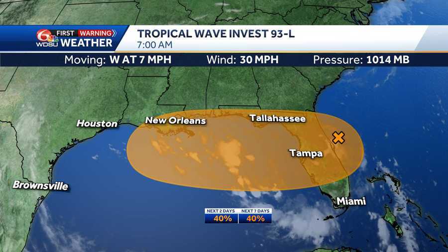
7 am Update- The National Hurricane Center (NHC) has been monitoring an area of low pressure, now identified as Invest 93-L, and now have a 40% or medium chance of development.
The National Hurricane Center is closely watching an area of low pressure just off the east coast of Florida. This disturbance is expected to drift into the northeastern Gulf by late tonight or Wednesday morning, with potential impacts for Southeast Louisiana starting Wednesday afternoon.
Conditions are marginally favorable for tropical development, but some gradual strengthening is possible as it moves through the Gulf. Even if it does not become a named system, this disturbance is expected to bring a surge of tropical humidity into the region, which could lead to rounds of heavy rainfall and localized flooding to Southeast Louisiana starting late Wednesday, Thursday, Friday, and possibly into Saturday.
Forecasts are already showing signs of higher rain totals building into parts of Southeast Louisiana and the Mississippi Gulf Coast, particularly in low-lying or flood-prone areas. Several inches of rain may be possible depending on how the system evolves.
WHAT WE KNOW:
Chance of development over the next 2 days: Medium 40%
Chance of development over the next 3-7 days: Medium 40%
IMPACTS TO SOUTHEAST LOUISIANA:
Louisiana is likely to receive heavy rainfall starting Wednesday afternoon, Thursday, Friday, possibly Saturday regardless of tropical development.
Stay with the WDSU First Warning Weather team for all of your latest tropical updates.
READ MORE:A tropical disturbance could bring heavy rain to New Orleans. Here’s what you need to know